Bayview Community Center
The Bayview Community Center
is available for your events.
Please call (208) 683-8040 for more information.
Bayview Chamber
of Commerce
To join the Bayview Chamber of Commerce,
you may print this
and mail to:
Bayview Chamber of Commerce
P.O. Box 121
Bayview, Idaho 83803
Bayview Chamber
Reader Board
Reader Board is for rent.
Download form for instructions.

The History of Bayview Idaho
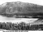
Bayview, Idaho lies on the southern shores of the biggest and deepest lake in Idaho; Lake Pend Oreille (pronounced - Pond-o-ray). Bayview is located in the North Idaho Panhandle, approximately 100 miles south of the Canadian border, about 30 miles north of Coeur d' Alene, Idaho and about 30 miles south of Sandpoint, Idaho (which is the intersection of U.S. Highway 95 and State Highway 54) and then east on Highway 54 another eight miles, through Farragut State Park.
At the end of the eight miles, proceed down the hill and into the town of Bayview at the western end of Lake Pend Oreille’s Scenic Bay. The magic and beauty of the view on your right coming down the hill is astounding.
In the early 1840s, there was a rather small settlement in the Columbia area of the Washington Territory known only as Squaw Bay (later called Bayview). Squaw Bay was located at the west end of a large arm of a lake called Lake Kalispell (also called Lake Pend Oreille). When some of Father DeSmets letters were published in Philadelphia in 1843, they referred to a church erected at a place near the Kalispell Lake after the Indians of the area. This is one of the earliest mentions of the
lake by the name Kalispell. About this same time, French trappers were
also calling Lake Kalispell Lake Pend Oreille also after the local Indians
they called Pend Oreilles because of the pendant ornaments they wore in
their ear lobes. The lake was not universally called Pend Oreille until the
mid to late 1860s.
Squaw Bay, at this time, was made up of just a few fur trappers’ cabins
and some tents. Those old mountain men, a few Englishman but mostly
Frenchman from New France (Canada), would trap the rivers and
streams of the northern Columbia area for the Hudson Bay Company
or American Fur Company or the North-West Company, all of which had trading posts established in the area. There were also a handful of Jesuit missionaries working with the native Indian tribes.
When trapping was not practical in the winter months, the mountain men would winter in Squaw Bay. The hunting was good but no services were available so they were strictly on their own. It is said that the Indian girls hung around the camps --- to trade food and clothing articles with the trappers and let us just say, help the trappers through the winters. Traveling into or out of Squaw Bay at this time, was strictly by foot or horseback. One would normally team up with a trapper or explorer who had been there and could act as a guide.
The next fifty years saw a slow but steady growth in the Columbia regions. Squaw Bay continued to be a wintering place for trappers. On July 2, 1864, President Abraham Lincoln signed an Act of Congress creating the Northern Pacific Railroad Company. The railroad was chartered to build from the Great Lakes to Puget Sound and its route followed the journey of the famed 1804-1806 Lewis and Clark expedition across the West. The railroad made real changes in the settlements of the Columbia country.
The first true settlement at the south end of the Lake Pend Oreille was Pend Oreille City, which appeared in 1864-65 at the southern most tip of the lake at what is now known as Buttonhook Bay. It was the second white settlement in north Idaho – the first being Seneaqueteen on the Pend Oreille River. Pend Oreille City was founded by Zenas Moody and consisted of five houses, a hotel, a bar and pool hall, and a grocery store. Pend Oreille City was an overnight stop for miners and freight merchants using the Lake Pend Oreille - Clark Fork River route to the northeastern gold mines.
Lake travel originated in 1866 following the construction of Captain Moody’s steamboat, the Mary Moody (named after his wife). This steamboat transported miners up the lake to connect with the Wild Horse Trail heading to the Wild Horse Mines in British Columbia or up the Clark Fork River toward Helena and the Last Chance Gold Mines of Montana. The Mary Moody would hold 55 passengers, 85 mules, and 10,000 pounds of freight at a cost of 13¢ a pound.
After the few years of its heydays during the gold rush of the late 1860’s, and the increased competition from Saint Louis merchant transportation of freight into the area, Pend Oreille City lost its importance. The Mary Moody was sold and then scrapped in 1876. This settlement then became known as Steamboat Landing sometime in the 1880’s. At that time the settlement continued to be used as a connecting point to
Rathdrum (then known as Westmont) and later Athol via a trail and
then a stage route.
Just east of the intersection of the junction of highway 95 on to highway
54 towards Bayview, a sign now stands on the south side of the road
commemorating historic Pend Oreille City. Approximately six miles to
the south of this sign at Buttonhook Bay on Lake Pend Oreille’s
Idlewild Bay, is where this city was located.
The town of Lakeview came into being in the early 1880’s when the first
prospectors filed claims. Bill Bell staked a claim and started a silver, lead and zinc mine. Simon Donnelly and Fred Weber established the Weber Mines in 1888.
The town of Chloride was located about 4 miles uphill of Lakeview and was the site of a gold mining boom about 1890. A miner leaked a false story about a rich gold find at Chloride to a San Francisco newspaper, and a stampede began. Many claims were filed and Chloride had a brief boom, but little ore was found and the town quickly died. Lakeview continued to flourish due to success by Weber and subsequent limestone mining operations.
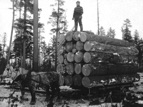
Squaw Bay continued to be a wintering place for trappers and a gathering point for loggers and trappers. Sometime after the 1880’s the focus shifts to Squaw Bay as the major settlement at the south end of the lake – probably due to the start of increased logging business.
By mid-1881, railroad gangs were completing sections of track from Spokane Falls to north Lake Pend Oreille and by the spring of 1882, grading crews had crossed into Montana proper, following the surveyors and working southeast along the Clark Fork, aiming for Missoula. The rail head at Athol was developed. The work force of nearly 4,000 men, with over 2,600 Chinese, were creating boomtowns of saloons, restaurants, flop houses and tents at the various construction sites.
In 1882, the settlement of Hope was established and named after a Dr. Hope, a Veterinarian who worked for the Northern Pacific Railroad. Brails of logs were towed across Lake Pend Oreille to Hope, for loading onto the Northern Pacific Railroad. Hope was the main city on the lake until about 1900.
In March of 1884, Idaho Territory was established by an Act of Congress.
Squaw Bay in the mean time was developing into a rather nice summer resort. Hotels and cottages had been erected and its shoreline was being developed to handle steamboat moorage to allow better lake transportation. In 1894, the settlement of Squaw Bay became known as the town of Bayview.
Between 1900 and 1905, D. C. Corbin established the Spokane International Railroad and over 145 miles of track was laid into Idaho entering near Hauser and running to Athol then on to Bonners Ferry where it connected to the Canadian Pacific Railroad
Steamboats met the needs of miners, railroad contractors, homesteaders, lumber companies and tourisst. There were about 80 steamers and tugboats serving the area. By 1905, a small mail and excursion steamboat established an all day cruise from Bayview to Sandpoint. In 1908, the Northern Navigation Company placed the steamboat ‘Northern’ into operation. The Northern was a double deck, 102-foot long mail, and passenger boat and was the queen of the lake for twenty years. Its career ended in flames in 1928.
In 1910, a group of Spokane businessmen formed the Prairie Development Company and plotted the town of Bayview – promoting it as a tourist destination and resort Mecca. D.C. Corbin extended his Spokane International Railroad to Bayview in 1911. This allowed lumber and limestone to be transported directly to Spokane.
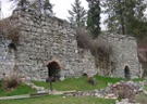
In the early 1880s, limestone deposits approximately 200 feet thick were found first across the lake at Lakeview and then at Bayview. These limestone deposits were the remains of fossil invertebrates that lived in a Cambrian sea almost 550 million years ago. The International Portland Cement Company began mining the limestone in Lakeview and the Spokane Lime Company and
later the Washington Brick and Lime Company did the mining in
Bayview. The quality of the Bayview and Lakeview lime deteriorated,
as Portland Cement raised its standards, forcing the quarries to close
in the 1930s. In 1936, the railroad spur to Bayview was abandoned.
Kilns, such as the five still visible on the Bayview north shore were used
in this mining operation.
Mail delivery on the lake goes back to the first steamboats in the 1880’s,
which carried mail, passengers, and goods. Mail is still transported
from Bayview to Lakeview and lakeshore residents all the way up to Kilroy Bay. Jim MacDonald operated that mail run from 1953 to 1965. Today, Wes Jones makes the daily run leaving Mac Donald’s Resort moorage. One can sometimes get a ride on a space available basis.
Farragut State Park is located four miles from the intersection of highway 95 and highway 54, toward Bayview. And PLEASE, drive slowly through Farragut State Park, as there is a large population of deer and they like to cross the roads at dusk and in the early mornings.
Eleanor Roosevelt allegedly noticed Lake Pend Oreille on a flight from Washington, DC to Seattle. She was aware of her husband’s search for a secure inland naval training site and mentioned the location to him. President Franklin D. Roosevelt made a secret trip to the area and in March of 1942, he selected the Lake Pend Oreille shoreline as the site for the second largest U.S. Naval Recruit Training Facility.
This site was named after the Civil War Admiral David G. Farragut. An award of $64 million was made to the Walter Butler Construction Company to complete this project. The project employed over 22,000 workers and required that roads, rail extensions (from the Northern Pacific Railroad), telephone and power lines be brought into the center.
Within five months, the first boot camp was established. This training facility quickly became the largest city in Idaho with over 55,000 recruits. Between 1942 and 1946, over 290,000 recruits were trained here. Approximately 850 German POWs did the gardening and maintenance services. Farragut Naval Recruit Training Facility was decommissioned in June of 1946. The park visitor center has an interesting display of memorabilia from that era.
The Farragut College and Technical Institute, a 2-year vocational college, open its doors on this property in 1946 with 300 students. By 1947, this college had an enrollment of over 900 students and 40 teachers. However, the college did not reopen in the fall of 1949 due to financial problems.
In 1964, the Farragut State Park was founded by an exchange of state land for federal land. It is now a 2,700-acre preserve with campgrounds, trails, boat dock and even has a small airfield for radio controlled model aircraft. One can even see mountain goats grazing on the cliffs below Bernard Peak across Idlewild Bay.
The U.S. navy still has a presence in Bayview at the tip of Scenic Bay. This is home to the US Naval Surface Warfare Center’s, Acoustic Research Detachment. Due to Lake Pend Oreille’s 1,200 foot depth in this area, this lake is uniquely useful for deep water acoustic testing, using remotely controlled submersible craft. It is involved in research and development of methods to make ships and subs operate more quietly. There are approximately 100 employees and contractors at this detachment, most commute from the surrounding areas.
Bayview's population is approximately 400 during the winter months and can grow to over 1000 during the summer. Many retirees follow the sunshine south during our long cold winters, however, those remaining enjoy the changing seasons and don't mind the snow shoveling.
The shoreline is lined with marinas and boats in covered and uncovered slips year round. There are also several sections of floating homes in four of the marinas.
Businesses such as banking, police, medical, etc. are all located in Coeur d'Alene and Sandpoint. Spokane, Washington is about 30 miles west of Coeur, d’Alene and has great shopping and theaters, sports arena, fine dining, and the Spokane International Airport.
The elementary school at Athol and the Timberlake Junior and Senior High School recently built in Spirit Lake are serviced by school bus from Bayview.
Lake Pend Oreille is known world wide for record size Kamloops Trout. . Additionally, the lake has Mackinaw, bass and perch in the shallow waters at the north end of the lake.
Bayview Daze is an annual festival held on the weekend closest to the 4th of July. There is a street market where the businesses provide special prices on their goods,and there is a great time for young and old alike. A street parade during the day on Saturday, a lighted boat parade at dusk, and a fireworks display at dark are the highlights of the event.
Bayview on Lake Pend Oreille - - A great place to live, work and play.
_________________________________________________________________________________
Excerpt taken from the book "Bayview the Early Years" written by Linda Hackbarth